

1. INTRODUCTION
The Chittagong Hill Tracts (CHT) region shares borders with Myanmar on the south and southeast, India on the north and northeast and Chittagong district on the west. It is completely different in physical features, agricultural practices and soil conditions from the rest of the country with mountains and beautiful landscapes. CHT is located between 21°-40? degrees and 23°-47? degrees north latitude and 91°-40? degrees and 92°-42? degrees east longitude. It is a unique territory with mountains and beautiful landscapes and socio-economically and culturally completely different from the rest of the Bangladesh. It roughly runs from North to South for 280 kilo miters. Geographically, the CHT region belongs to the hilly that branches off from the Himalayan ranges to the south through Assam and Hill Tripura to Arakan and Burma. The highest hills in the CHT are Tazingdong and Keokradong (4,034 ft high) located in Bandarban district.
The CHT region is divided into four valleys formed by the Feni, Karnaphuli, Sangu and Matamuhuri rivers and theirs tributaries and is marked out by chains of hills running from the south in a north-westerly direction. The Sangu and Matamuhuri rovers until they enetr the plains, run parallel to the ranges, and form two river-valleys. The Karnaphuli and the Feni run transversely across the main lines of the hills, and the valleys here are formed by the large tributaries of the Karnaphuli entering the river at right angles to its course.
The geographical condition favoured the CHT to be endowed with vast natural recourses like wood, timber, bamboo, sungrass, sandstone, limestone, natural gas, petroleum, coal, uranium etc. There are indications that the mineral resources, if extracted properly, would significantly contribute to national economy. The CHT area covers about one-tenth of the total land surface area of Bangladesh and the density of population is the lowest in the country. This suggests, the per capita availability of land in the CHT should be much higher than in the rest of Bangladesh. And, if one takes the per capita availability of land (without taking other issues into account) as an indicator of economic soundness, the people of the CHT should be economically much better off than the people in the rest of Bangladesh. The statistics indicate that the per capita income of the CHT is 320 percent higher than the national average of Bangladesh.1*
Apparently, the CHT have a good number of lands in compare to the rest of the Bangladesh. The CHT covers totally 13,184 sq. km. and consist of only 1,325,000 persons and density is only 190 persons per sq. km. (BCR: 1991). Whereas the density of the Bangladesh is 834 persons per sq. km. If one calculates the land pattern and look to the land account of CHT and compare it with the plain land pattern of Bangladesh, than CHT will come out the most populated area in the Bangladesh. In CHT 91 percent area covered by the Reserve Forest and Kaptai Lake Area only rest of the 9 percent of the land means 356.04 sq. miles or 572.99 sq. km. can legally be used for inhabitation.
1*. The Economy of the Indigenous Peoples of CHT by P B Chakma
2. CATEGORY OF LAND
At present there is a dualistic framework of land rights in the CHT: customary and national. A summary of the legal framework of the major land use arrangements is given below with references to applicable national legislation, in particular to CHR Regulation 1 of 1900.
2.1. Common Lands
The common lands are those which belong to the indigenous community with shared rights of access. The indigenous people have right to these lands and its resources, by virtue of their common ownership of these areas, and traditional economic activities such as fishing, hunting and gathering are carried out in these areas. Jum lands fall within this category, as do the lands used for orchards, grazing and for growing sungrass (used to make thatched roofs). The forests are also included within this category of mouza commons, and are the common property pf the indigenous community with equal rights of access, use and extraction. Traditionally no taxes were levied for the use of these lands.
Government does not formally recognize the rights of the indigenous people to the common lands as a collective right. It regards these lands as state-owned. They are also known as Khas lands i.e. state lands, while the forest Department categorizes these lands as Un-classed State Forests (USFs).
The CHT Regulation recognizes some of the rights of occupation and extraction of common lands, although taxes are levied for some extractive activities. The indigenous people have qualified rights to homestead lands, the extraction of sungrss (Rule 45A), the right to herd (Rule 45B), and the rights to Jum (Rules 34, 41, 42, 45 and 50).
2.2. Forests
The indigenous people of the CHT rely on the land and its natural resources, including the forests for their economic and spiritual well-being. Traditionally the right to use and extract forest produce was without any restrictions except those prescribed under customary law. However, during 1875-1882, the British administration initiated a policy of curtailing the rights of the indigenous people to the forests. This practice continues to this day. Initially, the forests were divided into two categories: (1) Reserved Forests and (2) Un-classed State Forests. However, in the mid-60s a third category was introduced: (3) Protected Forests.
2.3. Paddy lands
The lands which are used exclusively to grow rice are known locally as paddy lands, and are mainly to be found in the valleys and low lying areas. Traditionally, the majority of the indigenous Jumma people were Jum farmers, but during the time of Raja Dharam Bux Khan, when the capital of the Chakmas was still in Rajanagar, Ranguania in the foothills of Chittagong, the indigenous Jumma people learnt how to use the plough with the help of some farm labourers from the plains brought in expressly for that purpose by the Raja. The plough was gradually extended, and by the mid-19th century it became the preferred form of cultivation in the valleys and low lying areas of the CHT.
_____________________________________________________
2* Extract from ‘Land Rights of the Indigenous People of the CHT, Bangladesh’ by Rajkumari Chandra Kalindi Roy||
This was achieved in large part of the CHT. However, in 1960 after the Kaptai dam was built, a vast quality of plough lands in the CHT were submerged and over 100,000 people displaced. There remain only a meagre amount of land suitable for plough cultivation in the CHT and the district that once produced a surplus in food grains is now almost barren in this respect.
Strict records were maintained by the indigenous traditional authorities of the details of all plough lands, including name of owner, boundaries and other relevant information.
With the submersion of 40,000 acres of agricultural (paddy) lands by the Kaptai reservoir, there is an evemn greater shrtage of these fertile rice fields. In an effort to increase rice production, the lands situated below the high water marks of the Kaptai lake are also being cultivated, in addition to the valleys and low lying areas. These are known as fringe lands as they are on the periphery of the lake, and due to fluctuation of the lake level they are out of the water for period of time every year.
2.4. Grove Lands
With the construction of the Kaptai dam and the submersion of 40% of the agricultural land, the indigenous Jumma people had to seek alternative avenues towards economic self-sufficiency. The government made concerted efforts to introduce fruit farming in the CHT, instead of rice cultivation, which was the principal crop in addition to pulse and vegetables. The lands used for fruit farming and for forestry are known commonly as grove lands.
In the case of large gardens, leases are registered with the Headman and the Upazila Land Records. However, for the smaller gardens, there are no records of registration and the absence of ownership titles was a serious problem for the indigenous Jumma farmers in gaining access to credit and market facilities, in addition to providing documentary evidence of their rights to the land.
3. LAND DISPUTES IN CHT
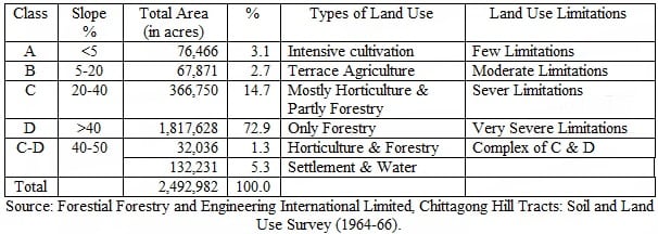
The economy of the people (particularly the indigenous peoples) is mostly based on agriculture. According to Land Revenue Administration Report of 1965-66, the total area of the CHT was 3,259,520 acres, the total cropped area was 223,002 acres, and the net cropped area being only 130,000 acres. That means, less than seven percent of the land in CHT is suitable for cultivation. The amount of land for plough cultivation is even less.
3.1. Construction of Kaptai Dam
The construction of Kaptai Dam (for Karnaphuli hydroelectric project) in the early sixties added to the already existing land crisis in the CHT. As a result of the Dam, an artificial reservoir (popularly known as Kaptai lake) was created which submerged 54,000 acres or 40 percent of the most fertile plough lands of the CHT. The net effect is further contraction of per capita availability of agricultural land.
Though the then government undertook programmes for rehabilitation of the displaced people, but due to scarcity of land the plough cultivators received hardly one-third of the land they lost as compensation, and that too was of inferior quality, and the Jum cultivators had to be content with smaller areas for Jum cultivation. The rest had to migrate to India, as no other alternatives were open to them.
3.2. Settlement of Bengali Muslims and forcible land grabbing
President Ziaur Rahman began state-sponsored migration of Bengali Muslim settlers into the CHT, providing land grant, cash and rations. This program was continued in secret, the international communities were not aware of this program till mid-1980s. More than four hundred thousands of Bengali Muslim were transferred into CHT. During the armed struggle, the successive governments of Bangladesh followed same policies against the Jumma people.
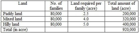
Since 1979, the government officially started to settle Bengali Muslim from the plain districts in the CHT to outnumbering the indigenous Jumma people and for using them (settlers) as human shield. The government declared that each settler family would be given Khas land free of cost according to the following scale including free ration for unlimited period:
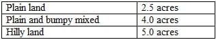
In order to comprehend the complexity of the potential problems inherent in this policy of population settlement programme, it is necessary to take into account the numerical magnitude of this situation. The following is an informal calculation based on an average family of 5 persons:
Indeed, no cultivable land was vacant for settlement so the settlers started to forcibly occupy the land of indigenous Jumma people. With an aim to uproot the Jumma people from their ancestral land, a long series of massacres and genocide were perpetrated by the Bengali settlers with the direct help of military forces. As such it left a horrible legacy of violence, rape, loot, murder, arson, abduction and forcible conversion, sacrilege of religion and forcible occupation of Jummas’ land and property as well as gross violation of human rights for more than two decades. Thousand of Jumma people were ousted from their own hearth and home.
3.3. Land leases for commercial lease
Huge tracts of land were given lease to non-indigenous outsiders in 19980s and 1990s for rubber plantation and other commercial purposes. Till today, no accurate information is available as to the exact amount of lands leased for such purposes and how these lands are being used. The Clause 8 of Part D of the Accord provides,
“Land allocation for rubber and other plantation: Out of the lands allotted to non-tribal and non-local persons for rubber and other plantations, the lease (allocation) in respect of the lands of those who did not undertake any project during the last ten years or did not properly utilize the lands shall be cancelled.”
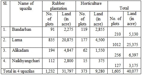
The Ministry of CHT Affairs ordered the Deputy Commissioners of the three hill districts to revoke such settlement, lease or transfer of land through a letter issued on 14 October 2000. But no concrete action has been taken so far. The leases given to the outsiders by the government in the name of rubber plantation and horticulture in Bandarban district alone is given in the following table:
3.4. Acquisition of 218,000 acres land for reserve forest
The Clause 26(b) of Part D of the Accord provides “Notwithstanding anything contained in any other law for the time being in force, No land, hill or forest under the controlled and within the jurisdiction of the Council shall be acquired or transferred by the Government without consultation with and the consent of the Council”.
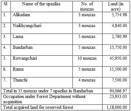
This provision has been included in the Act. But it is not adhered to and complied with by the concerned authority. The Deputy Commissioners of the three hill districts continue to acquire and transfer land in violation of the concerned provisions of the HDC Acts. On the other hand, in the name of afforestation, the government has unilaterally undertaken a programme to acquire 218,000 acres of land. Of this land, 94,000 acres of land alone fall under the Bandarban district. Thus, the Khyang ethnic people, the smallest and most deprived and disadvantaged Jumma group in the CHT, are on the verge of total eviction from their ancestral lands where they have been living and cultivating Jum from generation to generation. The lands illegally acquired by the government in the name of afforestation in Bandarban Hill district alone is given in the following table:
3.5. Land for militarization
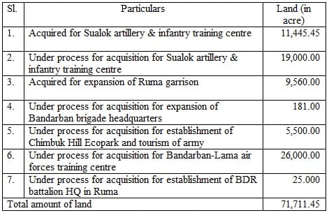
Huge amount of lands have been acquired for military purpose in CHT, particularly for the expansion of cantonment, expansion of camps, opening new Artillery Training Centers and new Air Force Training Centers. The land illegally acquired by the government in the name of military purpose in Bandarban Hill district alone is given in the following table:
4. CHT ACCORD, LAND MANAGEMENT AND RESOLUTION OF LAND DISPUTES
4.1. Land Commission
Clause 4 of Part D of the CHT Accord provides, “A Commission (Land Commission) shall be constituted under the leadership of a retired Justice for settlement of disputes regarding lands and premises. This Commission shall, in addition to early disposal of land disputes of the rehabilitated refugees, have full authority to annul the rights of ownership of those hills and lands which have been illegally settled and in respect of which illegal dispossession has taken place. No appeal shall be maintainable against the judgment of this Commission and the decision of this Commission shall be deemed to be final. This provision shall be applicable in case of Fringe-lands”.
The Land Commission has been formed in accordance with this provision. As per this provision, Anwarul Haque Chowdhury was appointed the Chairman of the Commission on 3 June 1999. But he passed away on 6 December 1999 before taking his responsibility. Later, on 5 April 2000, retired Justice Abdul Karim was appointed to the post. He assumed the office on 12 June 2000. Since then he visited his office only once in Khagrachari Hill district. Later, he too resigned the post on health ground. Since then the post remained vacant for around one and half year. After assuming the office, the four-party coalition government appointed retired Justice Mahmudur Rahman on 29 November 2001 without any consultation with the PCJSS and CHTRC. He too passed away in November 2007. Despite repeated demand from CHTRC to appoint chairman of the Land Commission, the Caretaker Government led by Dr. Fakhruddin Ahmed did not take action to this effect.
The new government, installed on 6 January 2009, appointed retired Justice Khademul Islam Chowdhury as the chairman of the Land Commission on 19 July 2009. After assuming in the office, Mr. Khademul Islam started in a dramatic fashion. Without convening any formal meeting of the Commission, he undertook a lightning tour of the three hill districts and convened meetings of the Commission for exchange of views. He unilaterally declared to conduct land survey in the CHT and to start hearing of land disputes without taking decision of the Commission. Since after the appointment of Khademul Islam Chowdhury, the only meeting was held on 27 January 2010 in Khagrachari. The meeting was ended without taking any concrete decision. After ending the tenure of last chairman Khademul Islam Chowdhury on 18 July 2012, the post of chairman of Land Commission still remained vacant for more than one year. On 26 September 2014 the government appointed a new chairman of the CHT Land Commission.
4.2. CHT Land Dispute Resolution Commission and its Act
The Accord stipulates formation of a Land Commission headed by a retired justice to resolve the land disputes in accordance existing laws, customs and practices in CHT. Land Commission was formed, but land disputes are yet to be resolved since more than 17 years have passed after signing the Accord.
CHT Land Dispute Resolution Commission Act was passed in 2001, but several issues contradictory to CHT Accord were included in this Act. After convening several meetings for more than a decade, on 20 June 2011 Ministry of CHT Affairs (MoCHTA), with the consultation with CHTRC, finalised 13-point amendment proposals of the Act and sent them to Land Ministry for taking necessary initiative to place Cabinet and Parliament for final adoption. At the last, on May 27, the Land Ministry placed a draft amendment bill titled “CHT Land Disputes Resolution Commission (Amendment) Act Bill 2013” before the cabinet, which approved it on 3 June 2013. On 16 June 2013, it was introduced in the Parliament for adoption. The Parliament sent it to the Parliamentary Standing Committee on the Land Ministry, seeking its opinion.
However, out of the 13 amendment proposals, only 10 have been incorporated in the “CHT Land Disputes Resolution Commission Act (Amendment) Bill 2013.” Among them, eight provisions have been placed in conformity with the 13-point proposals and the other two provisions have not been incorporated properly. These include exclusion of the word “practices” in clauses (a), (b) and (c) of the Sub-section 6(1) and the words “occupied land” in clause (c) of the Sub-section 6(1). Besides, there are three important proposals which are totally missed out in the amendment Bill 2013.
On 16 July 2913 the PSC took first hearing from CHTRC, PCJSS and other organisations, which demanded amendment of the Land Commission Act 2001 as per 13-point amendment proposals. The second hearing from representatives of the organisations (floated by local army authority) of Bengali settlers in CHT was taken place, in which they demanded abrogation of the CHT Accord and repealing of the CHT Land Dispute Resolution Commission Act 2001. The Parliamentary Standing Committee held its last meeting on 3 October 2013 but despite the issue of CHT Land Dispute Resolution Commission (Amendment) Act 2013 Bill topped the agenda, the Committee put it aside without any form of discussion. Present new government is to take any initiative in this regard.
The most important obstacle in this regard is the non-conformity of the Commission’s law with the provisions of the CHT Accord signed between Government of Bangladesh and the Indigenous peoples in CHT in 1997. On 26 September 2014 the government appointed a new chairman of the CHT Land Commission. This appointment is meaningless unless the amendment takes place.
The issue of disposal of the disputes over lands has landed in an extreme uncertainty. It is because of non-amendment of contradictory provisions of the land commission act, non-settlement of the disputes over the lands, every now and then, conflicts and communal riots are being occured in CHT centering the issue of the land disputes and the process of forcible occupation of lands belonging to the Jummas is going on unabated.
4.3. Cancellation of Land leases for Rubber Plantation and Other Purposes
Clause 8 of Part D of the Accord provides “Land allocation for rubber and other plantation: Out of the lands allotted to non-tribal and non-local persons for rubber and other plantations, the lease (allocation) in respect of the lands of those who did not undertake any project during the last ten years or did not properly utilize the lands shall be cancelled”.
This provision has not been implemented till today. Rather, allotments of land under this category continue unabated by the authorities. On 20 July and 18 August 2009, the meetings of the Parliamentary Standing Committee on CHT Affairs were held at Khagrachar and Rangamati respectively wherein it was decided to cancel the lease of the lands given to to the outsiders wherein no rubber plantation done or cultivation done thereof, as per the Accord. In light of the decision, the Deputy Commissioner of Bandarban in collaboration with Upazila Executive Officer, Mauza Headman, District Kanoongo and Upazila Amin, after physical verification, cancelled 593 numbers of leases for the reasons of violating the terms of reference by not growing plants. And the lands were brought under the government custody by issuing notice to the leaseholders under Memo No. je,pra,ban/Lease-1060/D/80-81/2009 dated 29/09/2009 signed by Revenue Deputy Collector (Revenue) for Deputy Commissioner Bandarban Hill District.
But it is painful and a matter of concern that at two-month length of cancellation of leases, the Bandarban District Administration, through the ill-practices of corruption, reinstated most of the cancelled leases of the lands to the leaseholders by issuing letter of Memo No. Je,Pra,Ban/Lease-1060(D)/80-81/2009 dated 19/11/2009. On the other hand, the remaining plots, though had been cancelled in papers, are still under occupation of the leaseholders. On the other side, the non-permanent and outsider Bengalees, under patronization and in collaboration with the concerned administration, in the name of lease, are occupying thousands acres of lands and giving threats to the local Jumma peoples asking them to leave the lands. In the meanwhile, in some areas, the Jumma villages were also attacked by way of employing the hired Bengalee laborers. As a result, the indigenous Jumma peoples are pulling their days in frights and anxiety. If the leases are not undone and the occupants are not driven away, the situation in those areas will get worsen to its extremity.
4.4. Hill District Council and Land Management
(a) Subject of Land and Land Management: As per clause 34(a) of this Part of the Accord, “Land and Land Management” is included in the Fisrt Schedule of the HDC Acts as a function of the HDCs. A proposal was sent to the government to transfer the responsibility of “land and land management” to the HDCs as per the CHT Accord. But till today, the subject has not been transferred to the HDCs.
(b) 64. Restriction on land transfer.- (1) Notwithstanding anything contained in any law for the time being in force-
(a) no land including the khasland suitable for settlement within the jurisdiction of Rangamati Hill District shall be leased out, settled with, purchased, sold out or transferred otherwise with the prior approval of the Council;
Provided that, this provision shall not be applicable in case of Reserved Forests, Kaptai Hydroelectricity Project area, Betbunia Earth Satellite Station, state-owned industries land recorded with the Government.
(b) No land, hills and forests under the control and jurisdiction of the Council shall be acquired or transferred without consultation and consent of the Council.
(2) The Council shall supervise and control the functions of Headmen, Chainmen, Amins, Surveyors, Kanungos and Assistant Commissioners (land).
(3) Fringe land in Kaptai Lake shall be settled with the original owners on the priority basis.
(c) Subject of “Protection of Forest except Protected One”: CHT Accord vests the subject “protection of forest resources which are not protected by the government” on the three Hill District Councils (HDCs). However, it is yet to be transferred to the HDCs.
(d) Collection of land development tax: Section 65 of Hill District Council Act on Collection of land development tax stipulates, Notwithstanding anything contained in any law for the time being in force, responsibility of collecting land development tax from taxable under the jurisdiction of Rangamati Hill District Council shall be vested with the Council and the said collected tax shall be credited to the Council’s fund.